Having cruised around Prince of Wales Island in June 2016, the crew of S/V Aurora would like to share notes and encourage others to make the trip. Since there’s no current cruising guide to this area, we’ve tried to collect key missing details.
The information in the Second Edition of Exploring Southeast Alaska by Don Douglass and Réanne Hemingway-Douglass is indispensable for anchorages but a decade out-of-date on docks. Today the Island is well served with new harbor facilities operated by Prince of Wales’ “cities”, sometimes jointly with Native Corporations.

For current information we turned to the 2016 Visitor Guide issued by the Prince of Wales 2016 Visitor Guide issued by the Prince of Wales Chamber of Commerce. While this publication is oriented to visitors traveling by ferry and road, it lists harbormasters’ phone numbers and includes good information on population centers.

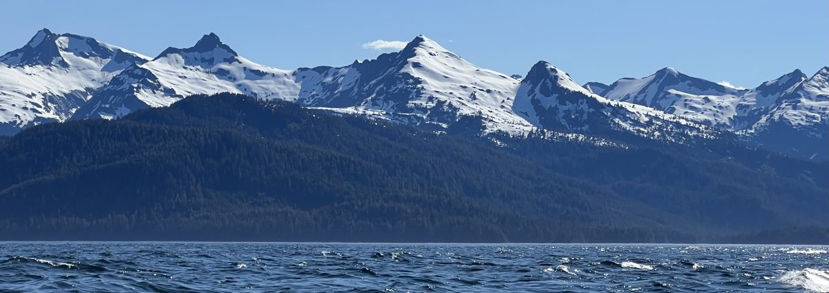
Prince of Wales offers wilderness we’ve found nowhere else in Southeast Alaska. The third largest island in the United States lies wholly within Tongass National Forest and has only 3700 inhabitants. Unlike the roadless Admiralty, Baranof and Chicagof Islands, Prince of Wales has roads connecting settlements on its east and west coasts. In this respect Prince of Wales looks inward: roads enable a single electrician or plumber to serve most of the population. Scheduled floatplane service fills the gaps, delivering mail and picking up passengers. Each of the destinations not served by roads maintain helicopter pads and volunteer emergency medical service teams.

The ferries of the Alaska Marine Highway do not serve the island; rather the Inter-Island Ferry Authority provides daily roundtrip service between tiny Hollis and Ketchikan. By and large the traffic is local, devoid of any large cruise ships. All in all, the light footprint of this transportation system has left virtually all of the POW’s thousand mile shoreline unmarred by infrastructure.
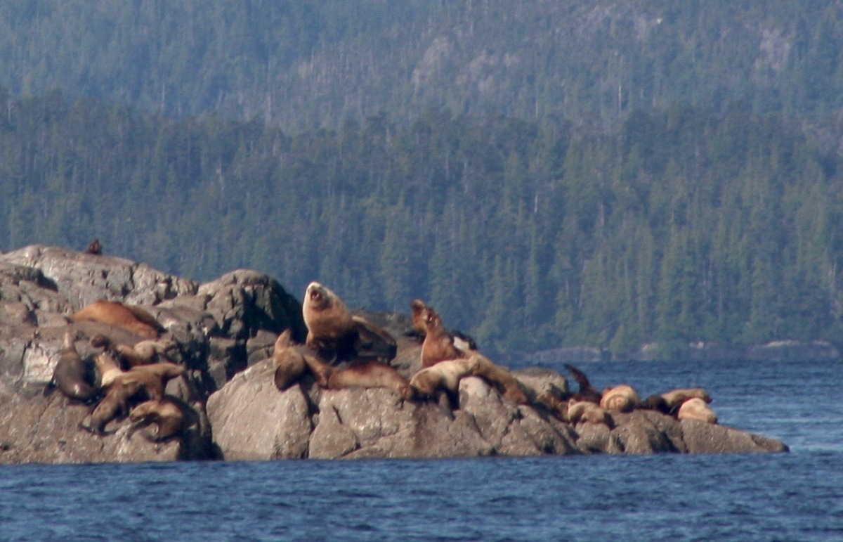
Cruising around Prince of Wales means a spectacular sweep of natural beauty teaming with wildlife: whales, dolphins, porpoises, sea otters, seals, sea lions, eagles and heron. Its docks and harbors offer opportunities to meet the people – the Haida,the Tlingit, the gill netters and the trollers. In future blog posts we’ll share our stories and document our anchorages and the passages. Now let’s circumnavigate POW counter clockwise and provide information on visiting the Island’s communities.
Hollis Population 165
Hollis is where the Inter-Island Ferry for Ketchikan leaves every morning at 8am and returns in the evening at 6:30pm. Th 35-mile trip takes three hours each way. Houses dot the shoreline of two coves off the south arm of Kasaan Bay. Unfortunately, it is not an inviting overnight destination. The bay where the ferry calls features a floatplane dock but no other moorage, not even for dinghies. The much larger bay to the south is shallow and seems threatened by williwaws from nearby hills. This is the only place we visited where the 2007 assessment of the Douglasses, who also did not dock here, still holds. “It has been reported that the Hollis Dock is extremely small and usually filled with local boats.”
According to the POW 2016 Visitors Guide this unincorporated community founded in the 1890s as a mining camp offers these additional services: emergency medical services, public telephone, library, accommodations, RV service, and boat launch. More at the website of this unincorporated community- www.hollisalaska.org.
Kasaan Population 65
Located on the northeast shore of Kasaan Bay, the Organized Village of Kasaan is home to members of the Haida First Nation, whose ancestors migrated north from Canada’s Haida Gawaii, until recently known as the Queen Charlotte Islands. They founded “Old Kasaan” seven miles away and in 1976 incorporated at the present site, which had since the late 1800’s hosted a mining camp, sawmill, postoffice, and store and later a cannery that operated until the mid-twentieth century.

While somewhat unpromising at first glance, Kasaan is a must see cultural destination for Inside Passage cruisers. At the end of a trail through heartbreakingly beautiful old growth forest (which hides the second or third growth struggling to cover nearby hills) lies an enchanting totem park and a historic longhouse which is to be rededicated with a once in a lifetime ceremony late this summer. Here’s the story as recounted in the 2016 Visitors Guide.
A two-third mile walk on a forest trail leads to Kasaan Historic Totem District and Chief Son-i-Hat Whale House or Naay I’waans. “The Great House” built around 1880 is the only traditional Haida longhouse in the U.S. In the 1930s, totems from the old villages were moved to the totem park. Between 1938 and 1940, Civilian Conservation Corps carvers restored the longhouse.
Kasaan offers a unique eco-cultural tourism experience in 2016…The Whale House and its house posts have undergone extensive renovation by a team of Haida and Tlingit carvers since 2014 in a joint project of the village corporation, Kavilco, and the tribe, the Organized Village of Kasaan. To celebrate restoration efforts and to honor this historic time for the Haida people of Kasaan, the tribe plans a rededication event for September 3, 2016. For information see http://www.kasaan.org or call 907.755.2261.

Visiting cruisers are greeted by brand new sturdy docks with the essential safety features but no electricity. At one end is the float plane base and the other a hefty float to accommodate small cruise ships, such as the 49 passenger Baranof Dream operated out of Sitka by the Tlingit First Nation. At the time we visited in June, there was no opportunity to pay moorage. Support for the Whale House Rededication, however, can be made online. The tribal newsletter covers the carvers’ progress and things to come.
Kasaan has a clinic, emergency medical evacuation, float plane service, a fine small library, a school, a green house with traditional and hydroponic vegetable gardens, two 2-bedroom vacation cabins, and a new Totem Trail Café. More into at www.kaasan.org.
Thorne Bay Population 500
Lying at the end of a long bay behind a nearly hidden entrance, Thorne Bay offers excellent moorage, unrivaled by anything we’ve seen elsewhere. Brand new floats are broad planked with 9-inch toenails and have electricity, water and the full range of safety features: fire extinguishers, life rings, permanent “swim” ladders, and, at the top of the covered ramp, a bright yellow locker with “Kids Don’t Swim” life jackets. Restrooms are particularly well designed for public use, the shower is roll in and all of the ramps are smooth. I believe moorage was 75 cents a foot.

Shane, the energetic and personable young harbor master is married to a teacher at the local K through 12 school and well integrated in the community. Thorne Bay was founded as a logging camp and incorporated as a residential community in 1982. The A&P (Alaskan and Proud) market is excellent. There are three churches, a liquor store, one of POW’s rare sit down dining restaurants but no bar. Currently, there’s no laundromat: one wonders if there is not a potential mini-business in dockside pick up and delivery. Other services include daily service by three float plane companies, emergency medical, library, sleeping accommodations, RV service, a gas station and a boat launch. Cell service is good.
Thorne Bay’s weak point is its fuel dock, tucked in a nearby shallow bay. Keelboats should purchase fuel only on a mid to high tide and, as we discovered, be prepared to hold as float planes land and disgorge passengers and mail. However, there’s an alternative: fuel can be delivered dockside in 5-gallon containers. Gary, owner of The Port, which runs the fuel dock and the post office, and the Tackle Shop at Throne Bay is very accommodating and highly knowledgeable about hunting and fishing.

With its current huge excess capacity and with moorage at less than $1000 annually, Thorne Bay is an option for cruisers who wish to winter over and fly or ferry in. More on these websites: www.thornebay-ak.gov and www.thornebayalaska.net.
Coffman Cove Population 200
Founded as a logging camp in the 1950s, the City of Coffman Cove was incorporated in 1989. When logging jobs disappeared the community had to reinvent itself and get into the business of recreational and commercial fishing. It’s a pretty but very unpretentious place. Modest vacation rentals and residences are strung along the shores of Clarence Strait with spectacular views of the white peaks beyond Wrangell.

The floats are good and the main ramp to them accommodates vehicles the serve the small commercial fleet of gill netters and trollers. Sport fishing is huge here, serving mostly Alaskans in pursuit of the annual personal use catch that will see them through the long winters. Small boats carry folks across the Strait for the day; a fleet of Lund dinghies takes them to the nearby, wildlife-rich islands.

We couldn’t raise the harbor master on the VHF but easily found dock space and paid fifty cents a foot, dropping a check in the box at the head of ramp. The sign there illustrates three ways to contact Harbor Masters at small Alaskan ports.
Coffman Cove docks are served by electricity but we didn’t connect to shore power as our solar panels love Alaska’s long days. As we were to learn, most electrical outlets belong to permanent moorage tenants. We heard a range of attitudes toward borrowing electricity from a vacant plug. Boats requiring power at smaller ports with part-time harbormaster would do well to contact local authorities during business hours.
Tiny Coffman Cove offers visitors a whole range of modest services. Bait Box Takeout has food and seating. The Riggin’ Shack is a general store with a variety of non perishable groceries. On Monday or Tuesday they get the fat weekend edition of The Ketchikan Daily News from the previous Friday. All the liquids are offered under one roof: Rain Country Liquor, the Dog House Pub and the office of R and R Fuels. There’s no fuel dock but the friendly owners of the business will run a hose to your boats or deliver diesel by dock cart in 5 gallon cans. There’s an excellent coin-operated laundry at the Ocean View RV Park, a short walk from the docks. Other services include an ATM, a clinic, emergency medical service, a float plane dock, and new monthly car ferry service to South Mitkoff Island.

Public phones serve Coffman Cove, which has no cell service. Dial 83 to use a prepaid card or 85 to use a credit. Free calls can be made for the weather (81), for commercial fishing safety reports (82) to call in an emergency spill (84) and to reserve a forest service cabin (86) or a place on the ferry (87).

Free wireless internet is offered around the clock at the Coffman Cove Library, which is staffed by an AmeriCorps volunteer under a program to bring more digital services to small Alaskan Communities. Local people may sit on the porch for hours or just pull up in their cars and quickly check their email. There much more on the official website of this vibrant community – www.ccalaska.com – and you can download a pdf of the brochure “Coffman Cove: Alaska’s best kept secret on Prince of Wales Island.”
Point Baker Population 25
At the northernmost tip of the Island, Point Baker offers an entirely different cultural experience, one immortalized for me by former fisherman-resident Joe Upton in Alaska Blues. In the third week of June this tiny floating community was crammed with gill netters preparing for a Monday through Thursday opening. There was no space at the dock and the small bay does not easily accommodate boats anchored out. On the recommendation of a fisherman, we rafted to a ferrocement boat, seemingly abandoned. No one asked for a moorage fee.

Port Baker is an unincorporated community of about 25 households. All public and commercial buildings are moored on the lee side of a 440-foot state dock with boats docked along the other side. A post office, community center, and small store operate very limited hours while the fuel dock,laundry and showers appear to serve boat and crews 24/7. A pub opens seasonally and there is some overnight accommodation. The state dock in good condition and offers a clear pathway whereas access to buildings is unkind to disabled cruisers.
There’s no cell service but there’s a public phone that requires a pre-paid card number. The large float plane dock doubles as a heliport. During salmon openings, fishermen raft their boats and repair nets there.
The evening before we pulled out of Point Baker, the Calder Mountain Lodge put up their welcome sign and opened for to serve sports fishing clients brought in from Petersburg. Their kind reply to my inquiry confirms they do not normally serve cruisers. For current info try the Point Baker Community association phone – 907.559.2204.
Port Protection Population 63
Port Protection is two miles and 2 minutes of latitude south of Point Baker but these two tiny fishing communities have no roads and are not connected. It lies at the end of a cove named for Wooden Wheel Johnson at the beginning of the last century. At mid century there was a trading post and a permanent community was established here in 1981 through the State of Alaska land disposal program.
We didn’t visit this year but enjoyed watching the low-key activity around this pretty and well-protected bay when there in 2014. We tied up at the free state float in the company of a variety of active and inactive local boats.

Seasonal services include float plane service, emergency medical, fuel, groceries, simple accommodations, a library and a public phone. The 2016 Visitors Guide recommends calling Wagon Wheel trading Post at 907.489.2222 for information.
El Capitan Cave Dock
Since this float does not accommodate cruising vessels, we simply mention it in passing. We do recommend, however, that all cruisers experience Dry and El Capitan Passes on their southbound journey and this route takes them right past this dock. It is owned by the State of Alaska and marked with a US Forest Service sign indicating the El Capitan Cave Interpretive site. Dinghies that tie up here are a mere 45-minute walk to the largest of the Islands’s more than 500 caves.The US Forest Service offers free tours of the cave several times a day in the summer. Visitors can reserve a spot for a specific tour by calling 907.828.3304 at least two days in advance. Maximum group size is six; minimum age is seven.

Boats can conceivably anchor nearby and dinghy in, although the nearest sound anchorage is Devilfish Cove, four miles south. An alternative would be to have a member of your crew drop others off and remain with the boat until the tour is finished 90 minutes to two hours later.
Naukati Bay Population 140
Located in the strait between the main Island and Tuxekan Island off Sea Otter sound, Naukati Bay lies about a quarter of the way down the southbound route. With so many exquisite anchorages in the area, we expect most cruisers move on to drop the hook, as we did. As the webpage of the community association boasts “Naukati Bay is the center for world class saltwater sportfishing, record black bear and Sitka black-tail deer hunting, breathtaking scenery, whale watching extraordinaire, sea kayaking and canoeing, spelunking, hiking, stream fishing for big steelhead trout.”

According to the POW Chambers 2016 Visitors Guide, “the newly constructed floating dock and boat launch are near the Naukati Bay Shellfish Nursery where oyster spat (seeds) are grown and provided to many oyster farms in the area.” Naukati Bay boasts float plane service, EMS, groceries, fuel, and an ATM. On the Fourth of July local kids compete to find huge skunk cabbage leaves, which dwarf them. For more information call the Naukati Bay Community Association at 907.629.4104 and visit the website www.naukatibay.com.
Klawock Population 850
The traditional summer camp for the Tlingit community from Tuxekan Island, it was chosen chosen as a permanent site by Chief Kloowah. It is also home of Alaska’s first cannery, established by San Franciscans in 1878, and its second oldest hatchery. Today, Klawock is best known for the twenty-one extraordinary poles in its totem park. There are replicas from the 1930s of poles that stood at Tuxekan as well new poles by contemporary Tlingit carvers, which have been raised with great ceremony by the community.

The well-built modern public dock and floats lie inside a sheltered peninsula with view of Klawock’s renowned totem park. On entering the harbor, your first see a set of floats between the cannery and a wharf with a large tidal grid. These busy floats belong to the tribal association. Go on into the harbor to the public facilities; the narrow channel is deeper than it first appears.

Because so many boats were out long term or for the day when we arrived, there was lots of space at the dock. Most of the spaces are rented, however, and owner’s lines may be on the dock but you can tie up and then check with the Harbormaster if you have not done so ahead of time. Electricity is another matter, as permanent tenants are already paying the meter and electricity is seldom offered. In all the POW ports except Craig, S/V Aurora was the only visiting cruising boat.
The Harbor Master’s phone is 907.755.2260 and the office is at the top of the ramp along with excellent restrooms with showers, baby changing tables and other amenities. I noticed that the women’s sometimes appeared locked but it’s a design flaw. The shower stall is spacious and ADA accessible but as stall door does not reach the floor, someone taking a shower might lock behind herself in the interest of safety. Rose Kato, Kwalock Harbor Master for seventeen years is retiring in July 2016. Transient moorage is a rather mysterious $11.45 a day for all boats regardless of size. Mariners interested in leaving boats to winter over in Alaska will be delighted to know annual moorage is a mere $11 a foot.
Craig Population 1,127
Craig is a charming little town with both the north and south coves of its harbor packed with tolling vessels, most local but many from the Puget Sound. The historic waterfront boasts an impressive series of wharves. Up the hill there are great views of the waters surrounding Craig’s compact peninsula. Known as West Craig, this is where you find the library, a traditional general store and chandlery atop a pier, the float plane dock, the popular Dockside Cafe, a convivial bar, and Voyageur Books and Coffee, with a fine selection of titles by Alaskan authors and books about Alaska. East of the harbor is a large Alaska Commercial Company supermarket and liquor store, a laundromat, and a whole range of services.
Most cruisers arriving from the north stop for fuel at the large sturdy Petro Marine float near the tank farm outside of town. Often rough waters can make tying up difficult but the staff is competent and helpful. This is a good place to confirm slip availability, even if arrangements have been made ahead of time. Craig is a port that practices hot berthing and asks boats to declare departures as well as arrivals. The Craig Harbormaster can be reached on 907.826.3404 or VHF 16. The office is located on the road that links East and West Craig and separates North and South Coves above year-round public restrooms with heated public showers. There’s much more information on the city website www.craigak.com.

Hydaburg Population 376
The largest Haida village in the United States, Hydaburg was founded in 1912 and is perhaps the best place in Southeast Alaska to appreciate the age-old culture and contemporary politics of a Native community.

Nearly a century before George Vancouver explored the area, a group of Haida people from Haida Gawaii – the former Queen Charlotte Islands – migrated to Prince of Wales Island. The first group settled at Kasaan on the east coast while others established villages on the west coast; in 1911 these villages came together at Hydaburg.
The village was incorporated in 1927 and governance passed to the Hydaburg Cooperative Association when it was founded in 1938. The HCA Mission is “to honor, strengthen and preserve our Haida Culture and Language through fostering healthy children and families who have pride and dignity in the community and culture, and by creating economic development opportunities for all our people.” This community appears to doing exactly that, with the HCA, the economic development-oriented Haida Corporation and The City of Hydaburg all playing a part.
At the time we were there, Hydaburg folks were busy planning for two major July celebrations. July 3rd and 4th are packed with races, parades and events to commemorate U.S. Independence Day. Each summer at the end of July, the Hydaburg Culture Camp brings together elders from this village and elsewhere to teach the Haida language, song, and dance and traditional skills of wood carving, weaving, beadwork, and food gathering and preparation. We were warmly welcomed to these festivities and hope to attend on a future cruise. In addition to organizing these events, Hydaburg folks will join their fellow tribe members at Kassan for the September 3, 2016 dedication of the Whale House.
Dominating the central water front in front of a large modern school, is Hydaburg’s totem park. The colorful poles are both intricate and bold. Some are well-preserved replicas of village poles that were carved in the 1930s while others are the work of contemporary artists. Recent years have seen a number of communal pole raisings. Master carvers remain busy in the Carving Shed at waters edge, sculpting works for the community’s new Tribal House being built nearby.
Hydaburg has a state-of-the-art complex of docks, floats, several hundred feet of breakwater with moorage space, and a boat launch with its own long float. While docks are well lighted, electric meters have not yet been installed at all slips and there are no restrooms or showers at the site. Hydaburg City Clerk Stacia Miller serves as Harbor Master. Phone her at 907.285.3761 to request moorage and pay fifty cents a foot at city hall. As there is currently excess capacity, cruisers are welcome to leave their boats over the winter. Hydaburg has excellent cell coverage; wifi is available at city hall and at the library in the school when it is open. There’s a small Alaska Commercial Company grocery, a health clinic, emergency medical service and a float plane dock but no fuel.

Getting to and from Prince of Wales Island
Crossing US-Canadian border requires approval from customs and border authorities before proceeding to other coastal areas. Northbound cruisers must pass U.S. Customs at Ketchikan, Alaska and southbound cruisers must pass Canadian Border Services at Prince Rupert, B.C. It’s important to become familiar with current official procedures as well as guidelines for navigating large ship traffic into and out of these two key ports.
Ketchikan lies 82 nautical miles north of Prince Rupert, a logical stop following the long passage along the coast before crossing the open waters of Dixon Entrance. Check tides and currents if you plan to exit Prince Rupert via the narrow and shallow Venn Passage.
After crossing Dixon, weather conditions and/or boat speed may make it advisable to anchor in US waters enroute to Ketchikan. This, however, requires prior approval from US Customs and Border Protection. You may contact US authorities in Ketchikan from Prince Rupert or by phone from your boat. The number is 907.225.2254. U.S. Customs officials normally approve overnights at Foggy Bay and will expect to see you the next day.

As soon as you tie up at a Ketchikan dock, all crew must remain on the boat until you receive clearance. U.S. Customs officials have always visited our boat to check our passports and personally welcome us. The wait has never been very long, particularly at Ketchikan’s Thomas Basin, which is adjacent to the federal building. You’ll probably want to spend the night before continuing up Tongass Narrows to Chatham Strait and the east coast of Prince of Wales Island.
This requirement to enter the United States at Ketchikan and Canada at Prince Rupert is why most cruisers take a counter-clockwise route around Prince of Wales.
Cruisers leaving the west coast of Prince of Wales can anchor at the south tip of the Island before crossing the open waters where the Gulf of Alaska and West Dixon Entrance. Nicholas Bay offers good protection but be aware of poorly charted rocks beyond the main channel. Nichols Bay is miles from the Canadian border and just north of Haida Gawaii. Unfortunately the protected wilderness and rich First Nations culture of these islands can only be accessed after entering Canada at Prince Rupert.

Our passage from Nichols Bay to Prince Rupert in beautiful weather took over 13 hours. We set up an informal watch system to manage our stamina so we would be sufficiently rested to navigate Venn Passage, pass customs dock and moor or anchor for the night.
To pass Canadian Customs, the traditional option is to tie up at the Lightering Dock which lies somewhat isolated near the center of the Prince Rupert waterfront but with no access to land. From this unattended location you can call Canadian Border Services at 888.226.7277 using your cell phone or the phone on the dock. Your request will be processed by an official based in Ontario with a closed circuit camera view of your boat.
Canadian authorities recently started to allow cruisers to check in with customs as soon as they dock Prince Rupert. To the south of the Lightering Dock are Fairview Small Craft Docks and terminals for BC and Alaska ferries. Just north is Cow Bay, with a new marina of the same name and the Prince Rupert Rowing and Yacht Club, and beyond that the Rushbrooke Floats.
Cruising with differently-abled crew members
Unlike most sports teams, cruising crews accommodate a range of ages and abilities. And as cruisers age or find themselves in recovery from accidents, invasive treatments, or joint replacements, they are less likely to want to go hiking or squeeze into an airplane seat for a vacation in Europe, Africa or Asia. During our time on S/V Aurora, we’ve been considering the services offered to crews of mixed abilities and documenting the accessibility and safety of moorage facilities on the inside waters of the Pacific Northwest.

We were delighted to find that most of the harbors on Prince of Wales Island allow the user of a wheelchair or electric scooter to roll safely along a float, up the ramp, onto the wharf, and out into the community. Nothing in the informational literature or standard cruising guides had prepared us for this pleasant surprise. The harbors at Craig, Klawock and Thorne Bay, moreover, offer well-maintained restrooms with grab bars and roll in showers. By and large, stores carrying groceries and essential gear were also accessible.
The gateway cities of Prince Rupert and Ketchikan have also made improvements. Moorage along Prince Rupert’s waterfront floats over about 150 feet of water, where wakes, tidal currents and wind perpetually rock boats. Now all sections of the Rushbrooke Floats have been joined by metal plates and the ramp offers wheelers a smoother transition. The Prince Rupert Rowing and Yacht Club has a new ramp; while metal finger docks are still narrow and dangerous, staff helps tie up arriving boats. New in summer 2016 is Cow Bay Marina at Atlin Terminal with safe, accessible facilities: wide wooden floats with water, electricity, laundry, restrooms, and showers. Ketchikan has thoroughly rewired floats and added wide, covered, metal ramps at Thomas Basin and helpful, uniformed harbor staff visit boats to collect moorage.
We visited two important Prince of Wales sites maintained by the National Forest Service. The tour of El Capitan, one of the largest caves in the US, is open only to fit hikers over the age of seven. However, a related – and in many ways much more interesting site – is the Beaver Falls Karst Interpretive Trail. It demonstrates the dynamics and features of the ongoing formation of the Island’s sinkholes and caves. A beautifully laid out 0.7 mile boardwalk takes visitors through scrub forest, over muskeg, past pools whose acidic waters dissolve limestone, through dark old growth forest and over deep caverns adorned with exotic plant life and waterfalls. Detailed, illustrated interpretative signs are placed all along the route. The first specified this: “The trail was designed to be barrier-free to the extent possible without disturbing the site. The distance between the rest areas exceeds AA standards. Maximum distance between the rest areas is 300 feet with a maximum grade of 14% for 30 feet.”


Also impressive is how many communities lend life vests through the Kids Don’t Float. This was the brainchild of the Homer, Alaska Fire Department in 1996. Later the same year, the Alaska Department of Health, the U.S. Coast Guard and community groups collaborated to grow the program. Now life jackets for children, teens and adults are found at most docks. Look for them in phone-booth type lockers, trunks or loaner boards with attractive graphics and motivating messages.
Kids Don’t Float spread to Canada in 2003, supported by police, municipalities, and businesses. This is a good idea . Let’s work with authorities, ports and marinas, and civic groups to bring more Kids Don’t Float facilities to Washington and Oregon.
Map of Prince of Wales Island
This map is from the Prince of Wales Chamber of Commerce 2016 Visitors Guide, which is available free in print and online. While we primarily anchored out in the Island’s wilderness bays and coves during our cruise, we found this the best source of current information on POW’s unique communities. Folks at the Chamber can be reached at 907.755.2626 0r info@princeofwalescoc.org.
We’d like to hear from readers as well. Please share your thoughts below, both news of your discoveries and corrections we should make to our brief “Cruisers’ Guide to Prince of Wales Island.”
Bon Voyage and smooth sailing!


Will look forward to reading in a couple of hours. At last some news!
Sent from my iPhone
>
This is an amazing and beautiful resource! Thanks.
Please do Prince of Wales again next year so I can go with you! Sorry I didn’t do it this year. Dumb.
Thanks for doing this. Nice work!! We are planning on doing the circumnavigation of POW this year. We are very excited about the trip. This will be our 2nd trip to Ak.