Tuesday 12 June 2018 Klemtu 52º35.6’ºN 128º31’W
We break the usual long passage north with a stop in Klemtu, where we land at the fuel dock and are greeted by a smiling Alan at the fuel dock. The folks at Shearwater has advised against filling up with their diesel until the huge shipment piped off a barge had settled in their tanks. Alan is welcoming an accommodating. When we request permission to drop anchor in Klemtu’s small bay, Alan says, “You could just pull back onto that extension of the fuel dock.” Oh good. A leg-stretch in this interesting First Nation village without having to inflate the dinghy. When I go up to the office on the dock to pay, Alan asks if I’ve visited Klemtu’s Big House. I haven’t. He has me copy down the phone number of Shane Robinson, who can guide me.
And that is a story still to be written.
Wednesday 13 June 2018 Lowe Inlet 53º33.4”N 129º34’W

We leave Klemtu at 6am and twelve and a half hours later drop anchor in Lowe Inlet. This can be a challenge but we nail it, our anchor grabbing the mud on a single narrow goldilocks band between shoal and depths.
Thursday 14 June 2018 Kumealon Inlet 53º52’N 129º58’W
The rising tide in Lowe Inlet entitles us to a mid morning start and a strong favorable current north on Grenville Channel. I sit on deck leaning back on the mast where I can look out for logs and signal to Jack, who zigs and zags around them. Twice a month, when the moon is full or new, spring tides float the drift from shore into our path.
Into Kumealon Inlet tonight, 23 vertical feel of water will flow in and out – six hours to arrive and six to depart. Again we must lay down the hook in the sweet spot, which is just off a rock wall where you can see the rise and fall with your own eyes. We succeed.

Friday 15 June 2018 Cow Bay, Prince Rupert 54º19’N 130º19’W
The new Cow Bay Marina has space. Owner Robin Beattie and his employee Noora are at the docks to take our lines. Currents are strong here. We tie up in 150 feet of water and watch shore rise 25 feet with the falling tide.
In the fog that comes the next morning we can’t see shore. It will not be fun transiting the circuitous Venn Passage on a low spring tide in such conditions. In the end, the lack of visibility on the morning of our rest day enhances our joy when the next morning dawns clear.
Sunday 17 June Foggy Bay 54º56.9’N 130º56.4’W
Above 54º40’ ! Alaska at last. Jack has called ahead to US Customs and got us permission to spend the night here along with two other slow sailboats.

Monday 18 June 2018 Ketchikan 55º20’N 131º38.4’W
As we motor up Revillagigedo Channel we see our first giant cruise ship of the trip, then second, third, four, and fifth towering over the waterfront. Without a suitable dock the largest cruise ship (in the whole world it seems) – the Norwegian Bliss – is anchored out and lightering in its passengers to shore. Today this diminutive town of 13,000 people has nearly 13,000 visitors!
We duck behind the first of these behemoths expecting calm in Thomas Basin. There is none. Strong, noisy williwaws rush down the peaks. As we dock I manage to get the midline on a cleat but nothing else. Aurora fishtails into the neighboring boat whose occupants come out to help. Man rushes to stern, woman grabs a bow line. It takes us ten minutes of struggle to inch the boat in an get it tied up.

Ketchikan is 80º. To escape the heat and check my mail I take the city bus up to Ketchikan’s new library. The ride is pleasant, the chair comfy, the view spectacular, but Alaska libraries aren’t air conditioned. What was I thinking?
When the sun sinks and the big ships are gone, and the fishing boats return, and thing get convivial on the docks. Sage, who organized our rescue is a shipwright who lives aboard with his family. He gives us his card, which we tape to the nav station. It’s hard to find a ready shipwright in Alaska in the summer; Across the way from them on S/V Lionheart are Rachel and Jeff with their baby, toddler and teenager. They are moving from Prince of Wales, where Rachel taught all of Thorne Bay’s third, fourth and fifth graders, to the Olympic Penninsula. John and Jennifer of Cara Babbo visit, bearing fresh corn muffins: turns out they’ve just moved to Port Townsend, where it will be good to have them. Next visit is crew of Teas for Two – the third Foggy Bay boat – Ian from Victoria and Helen from the northern shores of the UK.
Wednesday 20 June 2018 Thorne Bay 55º40.9’N 132º31.4’W
Whew! We did it. Got into Thorne Bay. Jack on Navionics on iPad standing next to me at helm. Straight line zig zag. My knuckles white. Jack’s voice calm. “One or two more degrees to the right.” “Now hard turn to left and straighten out at about 275º.”

We’re the only boat on the guest dock. We tie up right in front of Toccata, which Sheryl and Greg spent 27 years building in Port Townsend. New Harbormaster, Ron, seems to know everything. Says Sheryl is doing the laundry and Greg is in crafting something in his shop on shore. Somehow we miss them but liveaboards Libby and Jim pay a visit. Once the largest logging camp in the world, Thorne Bay is a quiet community of 400 souls. Libby says 38 of them are named “Jim” and that the second most popular name is Sean/Shawn. Shows some demographic diversity, I say.
Thorne Bay has excellent, empty docks and a liquor store but no bar. Which makes it somewhat unAlaskan. Rachel the teacher and future home schooler suspects her family was “too hippy” for the place.
Thursday 21 June 2018 Exchange Island 56º12’N 133.04’W

Summer Solstice. A late afternoon west wind is strong enough to spins Aurora opposite the direction the incoming tide has pushed her. I let out 50 more feet of chain I pay attention to our GPS coordinates lest we drag. We don’t.
As the wind subsides and sun sinks, we enjoy drinks on deck. An enormous salmon jumps and splashes as a great blue heron, clearly outmatched, looks on in wonder.
Friday 22 June 2018 South entry to Rocky Pass 56º35’N 133º41’W
Lovely morning passage north behind the Kashevarof Island and into the vast Sumner Strait. Two hulking cruise ships steam south to disgorge thousands on the Ketchikan waterfront when the shops open. An orange blaze appears over the horizon off Pt. Baker. Not a ship on fire but a commercial trawler with its fishing lights on. A large work platform of a boat disappears down Prince of Wales’ west coast. Nothing smaller anywhere around.
We head for Keku Strait, which nothing larger than Aurora can transit. We’ve done it twice before. Cognizance of how tidal level and direction affect passage are essential, especially for the middle 20 miles sections known as Rocky Pass.
So we get the Douglasses’ Exploring Southeast Alaska: Dixon Entrance to Skagway: Details of Every Harbor and Cove. We rail against the outdated 2007 second edition, designed either to terrify or laud the courage of the authors: “Stories abound of good skippers who grounded or ruined their boats in Rocky Pass. Part of the problem is crappy editing by Fine Edge publications. They’ve left in pages of dramatic stuff written long before placement of aids to nav and dredging of a section near Summit Island in the early 00’s. Our aging chart includes 2007 datum and Jack updated our Navionics digital chart plotter just before the trip. Despite some magnetic disturbance at the north end of Rocky Pass, we should make it.
Saturday 23 June 2018 Kake 56º56.8’N 133º53.7’W
Make that Peace of Kake. Kake is a Tlingit village at the end of Keku Strait where we are relishing modest triumphs. Our anchor held in the good mud of a vast shallow expanse of wind beaten water as we slept soundly. And when the tide was right mid morning we worked in tight collaboration to transit Rocky Pass.

Here on the good docks of this surprisingly empty harbor, we have been sandwiched by two other recreational sailboats. On starboard is Williwaw, owned by the surviving half of a cruising couple whose family members are delivering it to Anacortes where it will be sold. On port are three generations of Austrians on their third circumnavigation. “Via Panama?” I ask. “No, the Northwest Passage.” Wow. I tell them about Dogbark! and they mention seeing them on AIS earlier this week.
Sunday 24 June 2018 Baranof Warm Springs 57º05’N 134º50’W
Early morning fog persists all the way across Frederick Sound and up Chatham Strait. As we round the tip of Admiralty Island, a Stellar sealion surprises us with a huge splash off our port beam and explodes above the surface next to the boat on port side, an enormous salmon in his mouth. White; looks like a polar bear. Plays with his food. Throws it up in the air and snatches back in his jaws.
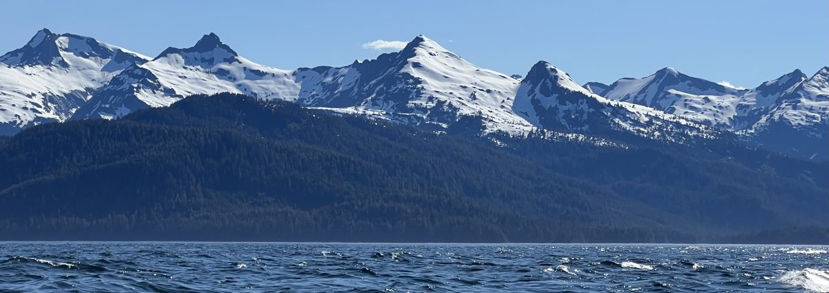
It’s late morning when we get close enough to the dock to see there are 45 free feet waiting for us. Everyone seems to sleeping. Finally the sun breaks over the snowy 4,000 foot peaks above us. Is there any corner of the good earth more beautiful than Baranof Warm Springs?
The docks come alive. We meet Sharon and John, who live aboard Gipsy Lady in Point Hudson. Stu in on Ripple a 26 foot gaff rigged boat built by the Northwest School for Wooden Boats. He’s buddy boating with Terry from Powell River, who has a tiny trimiran and helps me tighten the shroud we stretched when we bent the whisker pole and free the main halyard stuck in the mast.
The waterfall roars. We languish in one of the tubs in the bathhouse. When the seiners arrive, four big ones raft to the smallest, which hangs off the end of the dock. The Sitka Harbormaster under whose authority this small dock now falls would not approve. This is a party. Dogs and children spill out of the boats. Good to see beloved traditions endure.

Monday 25 June 2018 Schulze Cove 57º23.5’N 135º35.8’W
A long day starts with spectacular views as we make our early morning exit from Baranof Warm Springs.


We decide to push on in hopes of getting to the Sitka side of Sergius Narrows. In our 10th hour underway, we pull off into Deep Cove to figure out our low slack transit of the Narrows. We try to ignore the dread the Douglasses inspire in Cruising Southeast Alaska so turn to the usually sensible How to Cruise to Alaska without Rocking the Boat Too Much. Here’s what Walt Woodward writes:

Make no mistake about it, Sergius Narrows should be navigated for the first time by an inexperienced skipper only at high water slack; positively and without exception at high water slack. ….Let’s see if I can command your respect of Sergius. In the first place, it is one of only four passes listed in the Pacific Coast Tidal Current Tables for special statistical treatment: the others are Deception Pass, Seymour Narrows, and Isanotski Strait. All of them are awesome in the sudden and sustained way that maximum currents surge through them. The critical portion of Sergius is just 450 feet long, the length of the dredged channel that is 24 feet deep and only 300 feet wide. On one side of the channel is the rock wall of Sergius Point; the other, marked by a nun buoys, includes covered rock and a submerged rock. Through this aperture race mighty and variable-direction currents of almost six knots on the flood and 5.5 on the ebb. At slack water, however, the thing can be a mill pond for about ten minutes, plenty of time to get through. The only problem then would be other ships waiting for the same slack period. An Alaska state ferry can fill most of the channel.
Hmm. We’ve done Sergius twice before but can’t remember if it was high or low slack. No other boats around, at least not westbound. All our tide tables agree that low slack water is at 4:05 pm. And we’re not really inexperienced skippers.
So we go for it. Two powerful eastbound local boats push against the current to transit a couple of minutes early, leaving Serguis for us alone. We go in a minute before dead low slack and emerge a minute after it. Absolutely smooth. Around the corner we find the Alaska State buoy in Schulze Cove waiting for us.
Tuesday 26 June 2018 Sitka 57º03’N 135º21’W

Sublime passage through the swells of Salisbury Sound. The rain stops and the sun breaks through on the early morning trollers.
In Neva Strait we pass a couple of Sitka black-tailed deer, a small subspecies of mule deer that are a stable of the Alaskan diet.

In a narrow passage between Sitka’s first small islands, we pass Dogbark! and chat with Graeme and crew until they disappear into Olga Strait. They’ll head out across the Gulf of Alaska toward Dutch Harbor and continue north along the Bering Sea coast to Nome, where Janna, Talia and Savia will meet them. We’re getting their dispatches online.

